Arctic Sea Ice (part 6)
A bracing analysis of the poster child of globalist alarmism: what you always wanted to know about Arctic sea ice but were afraid to ask
In part 5 of this series I had a slight tussle with land surface temperatures [because I’m not a qualified climate scientist]. We jilted North America and placed our trust in the Scandinavian and Russian Arctic [making me guilty of cherry-picking]. In doing so we discovered a modest warming trend of 0.12°C per decade that has only been extent since 1980 [which means we’re all doomed unless we drive EVs and pay carbon tax], this following a cooling trend over the period 1935 – 1980 [an error that needs to be adjusted]. Prior to 1935 we observed another warming trend [they couldn’t read thermometers back then]. None of this makes sense [because we are not following the science], so I see no reason to flagellate ourselves with the CO2 = warming mantra whilst freezing to death in our 15-minute prisons and spreading bug paste on toast [these acts of self-sacrifice will save the planet].
Today I’m going to ignore that square bracket monkey-mind hokum because I’m not keen on totalitarianism no matter what colour it comes washed with or how many lives/economies globalism purports it will save. The climate is not my enemy, neither is the weather. As Billy Connelly, our great folk hero once said, “there’s no such thing as bad weather – only the wrong clothes.” I’d like to revise that this misty winter morning to read, “there’s no such thing as bad climate – only the wrong analysis.”
Sea Surface Trickiness
Sea surface temperature (SST) is a very tricky thing to measure. You’ve either got to drag something under a vessel, or stick a probe in the engine inlet valve, or dangle something from a fixed buoy or adjustable buoy array and hope that what fetches up is representative of that entire oceanic grid at that moment in time. The oceans are a pretty big place, so we can only hope to sample a teeny weeny fraction of their surface even with vast arrays of modern gizmos operated by a dozen billion dollar agencies. Go back 100 years and we’re talking about dragging a wooden bucket under a barge once in a while.
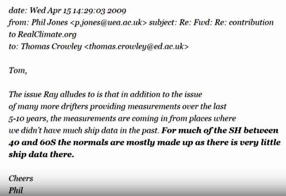
The fact that sea surface temperature is quintessentially a dataset full of missing values hasn’t deterred climate scientists from trying, and in many ways I sympathise with Professor Phil Jones of CRU/UEA when he jotted:
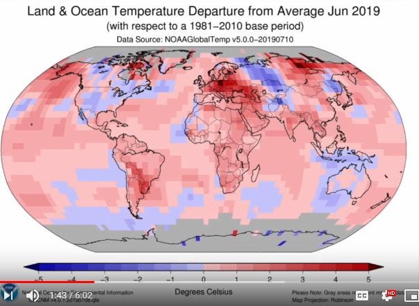
So next time you see a NOAA graphic like this…
…the first question you should ask is how many of those many gridded sections of Oceania are modelled (i.e. guessed) and how many are derived from actual observation. Perhaps I’ll dig into this hidden story in a future article, but for now I think it high time I baked a slide or two.
Hadley Centre
There’s an abundance of sea surface temperature (SST) data from 1978 onward, when satellites became the favoured survey method, with NOAA, NASA, ESA, ESRL, ERSST, ICOADS and others all throwing into the pot. The International Comprehensive Ocean-Atmosphere Data Set (ICOADS) is particularly wonderful, with global SST data records stretching back to 1884, but when it comes to the Arctic ICOADS SST data records only really get going in 1948.
No worries! If you want authoritative data on sea surface temperature stretching back to 1900 for the Arctic you have turn to the fabulous Hadley Centre, being one of the UK’s leading research institutes and a world leader in all things climate. Their landing page for observation datasets is as colourful as it is breathtaking in scope, the thought of which quite makes me giddy. If you want a rush of analytical adrenaline then have a look for yourself.
Somewhere down on that list you’ll see a hyperlink entitled HadISST – globally complete sea-ice and sea-surface temperature (updating) and this is where I went with my shopping trolley. The hard way to shop is handle all those many *.gz files yourself; the easy way is to use KNMI climate explorer and flip to the monthly observations page, which may be found here.
Reconstruction
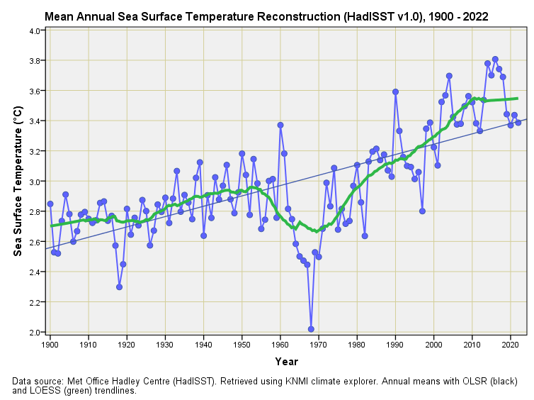
At this point we must note that the HadISST dataset is a reconstruction based upon the many patchy observational datasets the Hadley Centre handles. Ideally I’d have time to reconstruct an Arctic time series from the source data myself, but since I don’t I’m going to assume the boffins at the centre have done a better job of this than I possibly could and simply run my KNMI grid query to snaffle all of the Arctic reconstructed SST with a flick of the mouse. Herewith the result:
Isn’t that a lovely thing?
There’s a definite warming trend, and a linear interpretation of this (OLSR) leads to an estimate of +0.07°C per decade (p<0.001). Now that’s quite a mild rate of warming, being a great deal less than the 0.12°C per decade estimated for Arctic land surface temperature warming that I offered back in part 5.
This is rather intriguing for the classical position is that it is oceanic warming that is driving land warming. Either this is not always the case or land based Arctic weather stations are also prone to the urban heat island effect to the tune of 0.05°C per decade – I shall return to this conundrum in a future article.
If we now turn to that wiggly green snake (LOESS) this helps our eyeballs spot two things. We should have already spotted the dirty great dip in SST from 1960 – 1970 at a time when CO2 was rising (ouch!), and we should have noted that the warming rate from 1980 – 2020 is steeper than the warming rate from 1900 – 1950. Most curious indeed, and I shall be looking at the relationship between this and atmospheric CO2 concentration in a future article.
I am hoping readers have spotted a third thing – Arctic seas seem to have stopped warming from 2010 onwards or thereabouts at a time when human emissions were at an all-time high. Alarmists will not wish to read too much into this global weirding wrinkle, quite possibly because I’m wearing the wrong colour socks or something like that. Those with eyes to see will realise that the warming of Arctic waters is more complex than Net Zero and bug paste suggests.
After The Break
Now that we’ve got half-decent data for sea ice extent, land surface temperature and sea surface temperature on the kitchen table it will be an easy matter to pull up a freshly dug series for atmospheric CO2 (for background see this article and this article). We can then don our aprons and create some fabulous dishes. The excitement is real enough, for at this stage I have absolutely no idea what I’ll find as we look at the temporal dynamics between these four key ingredients.
Kettle On!


JD. That mid 60's dip in sea temperatures was real. At that time I lived in Swansea on the coast of the Bristol Channel. Walking my dog on the beach one winter afternoon, I was astounded to see large plates of ice, some 3 inches thick washed ashore. Ice age global cooling evidence was before my eyes!